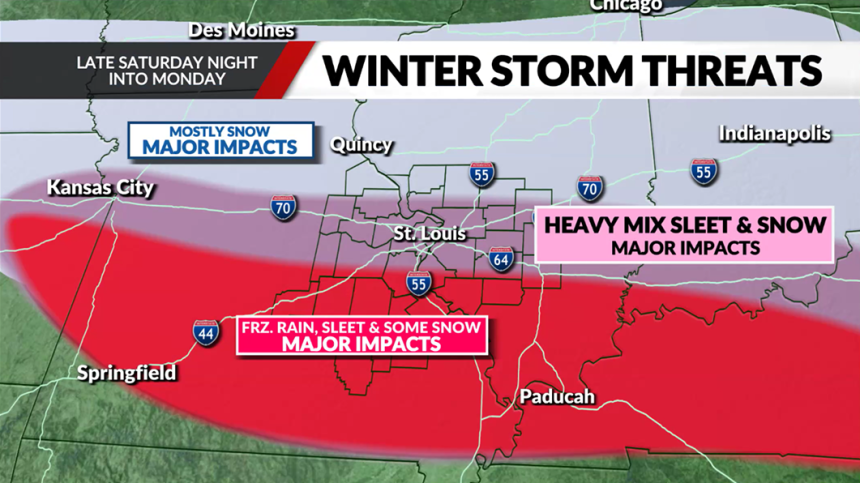
ST. LOUIS — A winter storm is expected to blanket the greater St. Louis area with snow, sleet, and freezing rain starting late Saturday night. This may disrupt travel and other activities through early Monday. The storm system is expected to bring a lot of winter weather to an area extending roughly 85 miles in all directions from St. Louis.
Timeline of Events
- Late Saturday Night (around 11 PM – midnight): Initial precipitation begins moving into the region
- Sunday: Full storm impact throughout the day, with various forms of winter precipitation
- Sunday Night: System likely transitioning to snow across most areas
- Monday Morning: Precipitation tapering off.
St. Louis radar: See a map of current weather here
Storm Impact Zones
Areas along and north of I-70 are projected to receive the heaviest snowfall, while regions further south—from Sullivan to Red Bud and Mount Vernon—face the prospect of a major ice storm. The area between these zones can expect a complex mix of winter precipitation, potentially cycling through heavy snow, sleet, freezing rain, and back to snow.

The storm will bring challenging winter weather conditions across the entire Fox 2 News viewing area. While meteorologists are still forecasting the accumulation amounts, they say that impacts to travel and daily activities are likely throughout the St. Louis region.
Temperature & Precipitation
The exact track of the storm and temperature will determine what kinds of winter weather fall across the area. Forecasters warn that this is a complex situation with warm air moving into the atmosphere that will create distinct zones of winter precipitation:
- North of I-70: Predominantly snow
- St. Louis and Jefferson County: Mixed precipitation zone (snow, sleet, and possible freezing rain)
- South of Festus: Higher potential for icy mix, primarily freezing rain and sleet with some snow
FOX 2 meteorologists will continue to monitor the system’s development. A more detailed forecast will be available as the storm moves closer to Missouri.


